Pick from the Past
Natural History, September-October 1922
![]()
Geology of New York City and Its Vicinity
By Chester A. Reeds
Associate Curator of Invertebrate Palæontology, American Museum
|
||

![]()
THE RELIEF features of the New York City district consist of several distinctly different types, which have been developed by natural forces on rocks of unequal hardness. Some of the rocks are unconsolidated sands and muds and are of comparatively recent date; others are stratified with alternating hard and soft beds, which lave been tilted or slightly folded and are older; still others of the same origin but far older have been so much altered and deformed during certain geologic periods that they have become crystalline and entirely changed in appearance, that is, metamorphosed. Volcanic rocks thick and homogeneous in character have also been injected into the area at different times, some very early, others later, but none very recently. These and some of the crystalline ones form the most resistant ridges. The distribution of the rocks is in the form of belts with a prevailing northeast-southwest direction.
- The essential relief features and physiographic provinces of the area are shown in a graphic manner on the relief map (above). They may be summarized as follows:
- The continental shelf, which represents the submerged margin of the continent, extends eastward from the New Jersey shore for about 100 miles to the 100 fathom line. Beyond that point the sea floor drops rapidly to the great and extensive oceanic depths of 2000–4600 fathoms.
- The Coastal Plain is that portion of the former submerged continental shelf which has been raised above the sea without apparent deformation. Three well defined elements of this plain appear:
- Its inner lowland, partly drowned in Long Island Sound, Lower New York and Sandy Hook bays, extends southwestward along the main railway lines through New Brunswick, Trenton, Philadelphia, Baltimore, and Washington;
- Its fall line features appear on the Delaware at Trenton, on the Schuylkill at Philadelphia, on the Potomac at the Great Falls above Washington, D.C, and on the James River at Richmond;
- Its cuesta forms the foundation of Long Island, the Atlantic Highlands, and the ragged front making up the hilly belt of southern New Jersey.
- The Newark Lowland is a plain developed on inclined weak strata consisting of red sandstones and shales of Triassic age. The intrusive sheets of resistant volcanic rock form the prominent residual ridges known as the Palisades, Watchung, Hook, Cushetunk and Sourland mountains, and Long and Rocky hills.
- The New England Upland is represented in the district by the Manhattan and Reading prongs. This upland consists of dissected and disordered crystalline rocks. The Manhattan prong extends down the east bank of the Hudson estuary from the Highlands to and including Manhattan Island. The north central portion of Staten Island is an outlier. The Reading prong extends as highlands from the gorge of the Hudson southwestward across New York and New Jersey to Reading, Pennsylvania.
- The broad valley to the west occupied by the Wallkill and Paulins Kill is a part of the great Appalachian Valley, which extends from Birmingham, Alabama, to Lake Champlain. It is one of the prominent subdivisions of the Newer Appalachian physiographic province.
- The narrow Kittatinny Mountain ridge dipping westward, represents the northeastern extension of the belt of newer and folded Appalachians of central Pennsylvania.
- The Alleghany Plateau appears west of the Delaware River. Farther north in New York State the Catskill Mountains represent a subdivision of this plateau.
|
||

Glaciation: The northern portion of the New York City district has been traversed at least four times by great sheets of ice which moved down from the Labrador center. These continental glaciers modified the drainage and the surface of the land over which they passed. The terminal moraine which represents the southernmost extent of the last ice field appears as a conspicuous ridge consisting of knobs and kettle holes on Long Island, Staten Island and New Jersey. It continues westward across the United States to the Pacific ocean near Seattle, Washington.
The drift bowlders and unsorted rock débris in the terminal moraine and northward give a clue as to the direction of ice movement. Large bowlders of crystalline rock from Jamaica and Hollis, Long Island, indicate that they were plucked out of the bed rock in the vicinity of Yonkers, Mt. Vernon, and other places in Westchester County, New York. Glacial-borne pebbles containing fossils and oolites have been found at Broadway and 191st Street. The fossils represent minute fragments of bryozoa and corals, of Devonian age, which are similar to those found at present in the Catskill Mountain region. The oolites, which are small, concentric spheres cemented together, resemble fish roe. They, too, come from up-state New York. On Staten Island, Long Island, and Short Hills, New Jersey, many large drift bowlders of sedimentary origin and containing numerous marine fossils were derived from the exposures in east central New York State.
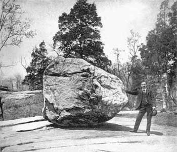
Each of the four continental glaciers of the Pleistocene epoch consisted of ice thousands of feet thick. They not only plucked out huge bowlders the size of a house and transported them long distances, but they also scoured off the soilcover in many places and left bare rock surfaces, roches moutonnées, little deserts in fact, on which no plants other than lichens can grow. A good example of a glaciated surface with an ice-transported bowlder resting upon it is the "rocking stone” in the New York Zoölogical Park, Bronx, figured below right.
|
||
Rocks held firmly in the base of the ice served not only as abrasives but also as etching tools. Deep parallel grooves in crystalline rock appear at various places on Riverside Drive, particularly on the south side of the Drive where it 1eaves the Hudson River at about 200th Street. These glacial striæ running northwest-southeast give the direction of ice movement. Many diabase bowlders from the Palisades found in Yonkers and New York City indicate that the ice moved southeasterly, diagonally across the Palisades and the Hudson River, as shown on the diagram.
A stream leaving the front of the glacier oftentimes contained a large volume of water and had considerable transporting power. Hence pebbles, sand, and fine rock débris were carried in considerable quantity. In most instances the streams deployed fanwise almost immediately on their emergence from the glacial sheet and the material carried from the ice was dropped close to the margin of the glacier. The fans formed by single streams were usually small, being from half a mile to two miles in radius; confluent fans were larger, varying from one to six miles in radius. The materials are somewhat sorted and stratified and are called outwash deposits. These deposits occur at short intervals along the southern margin of the terminal moraine. Towns built on some of the larger outwash plains are Plainfield, New Jersey; Flatbush and Hempstead, Long Island.
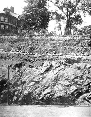 Exposure of glacial till, containing sand, gravel, and bowlders, in contact with Serpentine rock, at Castle Point, Hoboken. After United States Geological Survey, Passaic Folio, No. 157 |
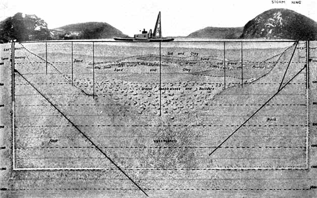 Cross-section drawing of the sediments in the Hudson River at Storm King Mountain, where is located the great siphon of the New York City aqueduct. From Bulletin 146 of the New York State Museum |
While glacial streams were depositing fan-shaped outwash deposits in many places along the ice front, a glacial lake, Lake Passaic, appeared to the south of the terminal moraine between the crescentic outline of the Watchung Mountains on the east and south and the New Jersey highlands on the west. The waters of the lake drained through the Muggy Hollow outlet at the southwest corner into the Raritan River valley. When the ice front retreated northward, the lake waters followed it and occupied the entire basin behind the Watchung Mountains to the west and southwest of Paterson, New Jersey. The numerous freshwater marshes of today, along the upper course of the Passaic River, cover Portions of the bed of this former glacial lake.
Great accumulations of glacial till, a mechanical mixture consisting of unsorted clay, sand, pebbles, and small bowlders, are found generally in the wake of the glacier. In the New York City district it varies from a fraction of a foot to 500 feet in thickness. A good exposure of it resting on Serpentine rock may be seen at Castle Point, Hoboken, New Jersey (above). It oftentimes fills the pre-glacial stream valleys and frequently covers the leeward side of hills and the lower areas. Test holes in the Harlem River at High Bridge show that the channel has been filled up from 80 to 111 feet by glacial drift and river mud.
The glacial drifts and sediments in the Hudson River gorge at Storm King Mountain have been found by drilling operations to be between 768 and 995 feet thick, with an average of 800 feet. In the vicinity of the Pennsylvania Railroad tunnels at 32nd Street, New York City, the sediments are 300 feet thick, with a possible greater depth in an untested section in midstream. In the Lower Bay deposits accumulated to such an extent that the mouth of the river was almost closed to large ships. Some $4,000,000 have been spent by army engineers in dredging the Ambrose Channel 2000 feet wide by 40 feet deep, so that the large ocean liners and other vessels may enter the harbor. From a point ten miles out from Sandy Hook to the edge of the continental shelf about one hundred miles distant, a well-defined river channel exists which increases in depth seaward. Near the brink of the continental platform it is 4800 feet deep. Glacial deposits appear over a portion of the course.
Recent Shore Deposits: Sandy Hook, Coney Island, and Rockaway Beach are pronounced coastal irregularities. South Beach and Midland Beach, Staten Island, are less so. These features are temporary for they represent initial stages in the process of coastal simplification. After the initial reefs and barriers have become land, the lagoons behind them are likely to be filled with sediment and organic matter, forming land.
The development of curved spits and beaches along the New Jersey and Long Island shores is worthy of consideration. In the vicinity of Long Branch, New Jersey, the sea cliff indicates wave erosion. The eroded débris is shifted northward by the waves and currents and piled up along the beach which terminates in Sandy Hook. The tendency of the hook to turn westward is due largely to the strong westward sweep of the winds and tides of the Atlantic Ocean. This has been going on for some time, for Sandy Hook is a compound, recurved spit. Rockaway Beach is also compound in appearance while Coney Island is simple. The same forces which drift the sediments north along the New Jersey shore are moving them westward along the Long Island coast in the vicinity of Rockawav and Coney Island. As Staten Island lies across the path of these waves, South Beach and Midland Beach represent a barrier or bar which has been built up by the waves near the line of breakers. That the prevailing direction of currents along the Midland Beach is to the southwest is indicated by the development of a spit in the vicinity of Great Kills. Beach deposition and straightening of the coast line is also in progress on the south shore of the Lower Bay in the vicinity of Port Monmouth New Jersey.
The estuaries and lagoons east of Port Monmouth are being filled with sediments derived from the land and the growth of vegetation, for, being in the lee of Sandy Hook and the barrier beaches, they are protected from strong sea waves. This is also true of Jamaica Bay, the Flushing Creek basin, Hackensack Meadows, Newark Bay, and the upper reaches of Arthur Kill. These bays and estuaries are the result of recent subsidence of the area. Thus the drowned lands, which now represent shallow sea floors, have been a factor in the placing and development of certain pronounced hooks and barrier beaches. The wind has also notably modified the deposits made by the waves and currents, for it has developed long ridges and sand dunes on the surface of the beaches.
In addition to the shore deposits which are of recent development there are rocks exposed in the New York district which have greater age and a more profound history. There are at least five series of them. While they are in close juxtaposition and have a well-established relation to each other, they are widely separated in origin by great intervals of time. Each series has had its normal period of development; the oldest, however, has suffered greater physical and chemical changes imposed upon it by mountain-making movements and other deformations which have affected it during the growth of the North American continent.
In passing from a consideration of the present shore development to the oldest series of rocks exposed in the area we go rapidly backward from the Age of Man through the Age of Mammals, the Age of Reptiles, the Age of Amphibians the Age of Fishes,
|
||

The Archæozoic Era: In the dawn of life a series of limestones and associated sedimentary rocks were laid down in Canada near Ottawa, which have been called the Grenville series. According to Professor Berkev, of Columbia University, certain metamorphosed rocks in the Manhattan and Reading prongs of the New England upland are contemporaneous in age. The Fordham gneiss exposed in the Bronx and Westchester counties and northward has all the physical characters of the Grenville series. It consists primarily of granitic and quartzose black and white banded gneisses and schists of very complex composition and structure. Interbedded quartzite and limestones and old igneous intrusions are also included. Note the position on the accompanying geologic map (left).
Overlying the gneiss series in a conformable manner at certain localities is the Lowerre quartzite named after the locality in South Yonkers from which it was first described. It is a thin, schistose quartzite which varies in thickness from a fraction of a foot to 100 feet and rarely out-crops.
This formation is followed by a coarsely crystalline limestone locally tremolitic, micaceous, and pegmatitic, which varies in thickness from 200 to 800 feet. It is called the Inwood dolomite after the lnwood section of the city at the north end of Manhattan Island. Good exposures of the Inwood dolomite occur in the valley north of Dyckman Street, for instance at Marble Hill station on the New York Central Railroad.
Conformable and overlying the Inwood formation is a coarsely crystalline mica schist, very thick, and pegmatitic, which is called the Manhattan after the extensive exposures on Manhattan Island. The Lowerre-Inwood-Manhattan series is regarded as late Grenville in age. This and the Fordham series constitute the originally sedimentary beds of the Archæozoic Era exposed in the New York City district.
The Proterozoic Era: Igneous Rocks: All igneous rocks of the crystalline area under consideration are younger than the sedimentary members since they have been intruded. But they are not all of the same age or kind. There are granitic stringers and sills which may date back to the close of the earliest of these sedimentary periods, since they partake of all the metamorphic changes that characterize these ancient strata including recrystallization and flowage. The most striking examples are the Yonkers granite gneiss, a sill, and the Ravenswood granodiorite, a boss. Some of the pegmatite streaks and basic intrusions belong to a period of more extensive metamorphic activity and penetrate the Inwood dolomite and Manhattan schist. Examples are the Harrison diorite, basic dikes, granitic dikes, bosses, and intrusions as shown on the accompanying geologic map (above). Serpentine, which is a metamorphic alteration product, has a like origin and distribution.
The entire basal series of rocks have been folded, crumpled, faulted, crushed, injected, intruded, and intensely modified by recrystallization, nevertheless. they retain the fundamental association and essential character of an originally sedimentary series. Many of the gneisses, a few of the schists, all of the granites and diorites are of igneous origin and occur as sills, dikes, or bosses, cutting the metamorphosed sedimentary members. They, too, have been greatly metamorphosed and are very ancient, perhaps late Archæozoic or Proterozoic.
 Slab showing passage of two Triassic dinosaurs after a shower. The raindrop impressions are represented by small pits. After R.S. Lull |
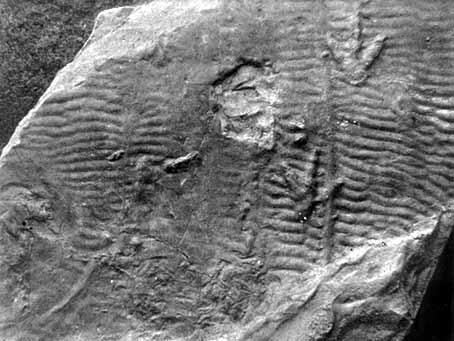 Impressions of the feet and tail of a Triassic dinosaur on a ripple-marked surface. Specimen from Pleasantdale, New Jersey |
The Palæozoic Era: The Palæozoic rocks and fossils, which represent a tremendously long period of time and follow the Proterozoic Era, are not found in the immediate vicinity of New York City. They appear, however, in great force in western New Jersey, New York, Pennsylvania, and the Mississippi valley states.
|
|||
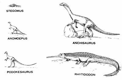
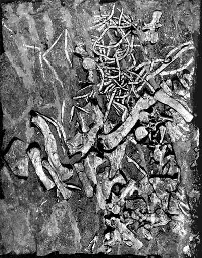
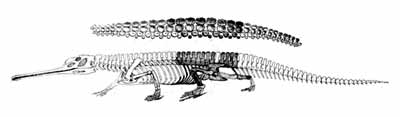
The Mesozoic Era, Triassic Period: From the Hudson River westward to the crystalline rocks of the New Jersey highlands occur a thick series of reddish brown sandstones, shales, and called the Newark group, which dip 10 to 15 degrees to the northwest. Near Philadelphia, Trenton, and New Brunswick, the Stockton, Locatong, and Brunswick formations have been differentiated, but not beneath the glacial drift cover to the northeastward. These sedimentary rocks were deposited in a trough or graben with faulted margins which extended southwestward from the Hudson River across central New Jersey, Pennsylvania, and Maryland into southern Virginia. In all probability a major stream with lateral tributaries occupied the depression. The region was presumably high and arid. Ripple marks, mud cracks, rain drop impressions, and footprints of reptiles are common, especially in the Brunswick shale, and indicate flood plain and shallow water deposition. Restorations of the dinosaurs Stegomus, Anomoepus. Podokesaurus, Anchisaurus, and Rutiodon (Rhytidodon), which inhabited this zone and the Connecticut Valley, are shown in accompanying illustrations (right). Only one skeleton, the Fort Lee Rutiodon (below), has been found near New York City. Fossil fishes and a small crustacean, Estheria ovata, have also been found. The fossil remains indicate Triassic age, the initial period of the Mesozoic Era, sometimes called the Age of Reptiles.
Three successive lava flows which were extruded during the deposition of the Newark beds have been subsequently faulted, flexed, and tilted into their present position. Since that event erosion has removed a great thickness of the sedimentary rocks and the upturned edges of the lava sheets are now exposed. The First and Second Watchung Mountains and Hook Mountain represent these three basaltic flows. The lowest, First Mountain, is about 6oo feet thick, Second Mountain 800 feet, and Hook Mountain 300 feet. About 600 feet of red sandstone and shale separate the first and second, and 1500 feet the second and third. Red Triassic sandstone and shale are also found above and below these volcanic rocks.
The Palisade diabase is a great sheet of igneous rock, from 50 to 1000 feet thick, which was intruded among the lower strata of the Newark group. It extends from Staten Island northward along the west bank of the Hudson River to Haverstraw. At its southern exposed extremity it is practically at sea level, while at the north it is 700 feet higher. Throughout most of its extent it presents an escarpment of high cliffs with vertical columns of rock which were developed during the cooling stage and which suggest the name Palisades.
Cretaceous Period: Stratified rocks which represent the closing stage of the Age of Reptiles rest unconformably upon the Newark group in New Jersey and upon the crystalline basal complex in Staten Island and Long Island. Except for a few exposures along the north coast and the interior of Long Island the Cretaceous sediments are hidden by glacial deposits of Pleistocene age. Their presence, however, is ascertained from numerous deep-well records. In the unglaciated area south of Raritan Bay they are exposed over extensive areas. Here three well-defined members appear, the basal Raritan formation of plastic clays, the Mattawan formation of clay marls, and the Monmouth, including the Rancocas and Mansquan formations of green sand and marls. Fossil marine invertebrates and plant remains indicating Upper Cretaceous age are found in some of these beds. The Cretaceous deposits of Long Island, which average 1550 feet in thickness, vary greatly in composition within short distances and are, on the whole, more sandy than those of New Jersey. An exposure may be seen at Elm Point on Great Neck, Long Island.
|
|||
The inclination to the southeast of the bed rock surface on which these sediments were deposited is about 40 feet to the mile in New Jersey, 80 feet near Oyster Bay and Huntington, and 40 feet at Port Jefferson, Long Island. The dip of the beds, which is the same as the slope of the unexposed floor, probably decreases toward the east and south. This old Cretaceous floor is still preserved inland in the crests of the Palisade and Watchung ridges, Schooley Mountain and Kittatinny Mountain of New Jersey and in the truncated folds of the Appalachian Mountains west of Harrisburg, Pennsylvania. Locally in Long Island the weak upper beds of the Cretaceous series have been greatly folded and contorted by the passage of the Pleistocene glaciers over them.
The cenozoic Era, Pleistocene Events: Four glacial and three interglacial stages are represented on Long Island. The periods of glaciation correspond to the Nebraskan, Kansan, IIlinoian, and Wisconsin of the Central United States, and to the Günz, Mindel, Riss, and Würm of the Alps Mountains. Locally they have been named by Mr. M. L. Fuller, of the United States Geological Survey, the Mannetto, Jameco, Manhasset, and Wisconsin stages and are represented primarily by gravel and morainal deposits. The only ones represented within the limits of the accompanying geological map are the Manhasset and Wisconsin. The out wash, terminal moraine, till, and retreatal outwash deposits of the Wisconsin stage are far more extensive and readily examined than the similar accumulations of the older stages since they were the last and cover in large part those made during the preceding glaciations.
The First Interglacial stage, the post-Mannetto, was long, for a great erosion unconformity exists. Following the deposition of the Mannetto gravel of the First Glaciation, there was a period of uplift and erosion in which the Mannetto was cut to a depth of 300 feet below sea level, as shown by the depth of the buried Jameco channel in Long Island. The great length of this period of erosion, indicated by the almost complete removal of the thick Mannetto gravel from the Long Island region, is in harmony with the time required for the cutting of the Hudson River rock gorge to a depth of 750 feet below present sea level. The gorge proper appears to be tilled solely with Pleistocene materials as indicated by the Storm King and other borings; hence, its cutting is to be referred to a date later than the deposition of the latest Tertiary beds in New Jersey.
The narrow, steep-sided and deep outer cañon of the submarine channel, if due to stream erosion, must be referred to an elevation of great magnitude, 4800 feet, occurring at the close of the post-Mannetto erosion stage. The great drops or falls in its beds are characteristic of a juvenile stream or old one which has been rejuvenated. As only the edge of the continental shelf was notched, the epoch of maximum elevation must have been brief.
During the Second Interglacial stage, the Yarmouth of the Mississippi Valley, the Gardiners clay was deposited in Long Island. It was followed by a transitional epoch represented by the Jacob sand. Throughout the time of the Second Glaciation, the Second Interglacial, and the Third Glaciation, the channel of the Hudson remained constantly below sea level. The deposits, which have a combined thickness of about 500 feet, doubtless obliterated the tipper reaches of the Submarine Hudson channel.
The Third Interglacial interval, the Vineyard, is represented by (a) a great erosion unconformity, and (b) the Vineyard formation, consisting of marine deposits and peat. The valleys in the Manhasset deposits, although somewhat modified and partly filled with the later Wisconsin accumulations, are known to extend some distance below sea level at mans’ points along the north shore, indicating a former higher position of the land. The present upper submarine channel of the Hudson, which has a depth at its outer end of 350 feet, suggests that, the land must have been elevated to that extent during the Vineyard interval.
There are no erosion channels referable to Wisconsin or post-Wisconsin elevation on Long Island. The upper end of the Hudson channel, however, between Sandy Hook and Rockawav Beach, has been obliterated in part by Wisconsin outwash and in part by the shifting of the sands by the littoral currents that now sweep along the coast.
Thus in this rapid survey we have considered very briefly the Archæozoic, Proterozoic, Palæozoic, Mesozoic, (Triassic, Cretaceous), and Cenozoic (Pleistocene) series of rocks as represented in New York City and its vicinity. They are replete with interest but they represent only a few isolated and incomplete chapters of the geologic history of North America. The long Palæozoic era, including the Age of Invertebrates, Age of Fishes, and Age of Amphibians, is not represented by sediments in the area of the geologic map (above). The Jurassic and Lower Cretaceous periods occupying the middle portion of the Mesozoic era, the Age of Reptiles, are also not represented in this district. Likewise the Tertiary series, corresponding to the Age of Mammals, appears outside the area. The Pleistocene glacial deposits, which are contemporaneous with the Age of Man, are rather fully represented but, as yet, no human remains have been found in them in this area or anywhere in North America.
Copyright © Natural History Magazine, Inc.