July-August 2005
![]()
Cold Fire
![]()
In Antarctica’s Dry Valleys, the deep chambers and conduits that
poured hot lava onto the surface are exposed as nowhere else on Earth.
![]()
By Edmond A. Mathez
|

The “we” in this band of Scotch drinkers included me and twenty-four other geologists. At the behest of Bruce Marsh, a geologist at Johns Hopkins University, and with the support of the U.S. National Science Foundation, we had assembled in Wright Valley, one of the McMurdo Dry Valleys of Antarctica—or simply, the Dry Valleys. The region is surely among the most remote, exotic, and starkly beautiful corners of the planet. In spite of the ice and snow that blanket the rest of Antarctica, Wright, Taylor, and other parts of the Dry Valleys are deserts, among the most waterless places on Earth.
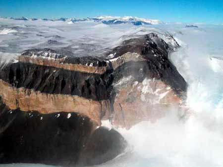
For the past decade, Marsh has been studying a labyrinth of basaltic rock spectacularly exposed in the walls of the Dry Valleys. The labyrinth is made up of dikes (sheetlike bodies of rock that cross the surrounding strata) and sills (bodies parallel to the strata). Basalt, a fine-grained black rock, is the most common igneous rock on Earth. It forms when the Earth’s upper mantle partially melts, and the resulting magma rises to places where it can solidify rapidly, either within the crust, as dikes and sills, or at the surface, as erupting lava.
The dikes and sills of the Dry Valleys are the remnants of a kind of plumbing system through which magma worked its way to the surface in a series of eruptions about 180 million years ago. Volcanic plumbing systems are rarely exposed at the surface. The reason is simply that around active volcanoes, lava covers everything. Even at old, inactive volcanoes that have been deeply dissected by erosion, geologists commonly see only the interior of the volcanic edifice, not the structure of the rocks below.
Exposed to view in various parts of the Dry Valleys, however, is a vertical slice of the dikes and sills immediately beneath the lavas, which cuts across layers of rock two and a half miles thick. Hence along the valley walls, geologists can see much deeper into the volcanic plumbing than they can almost anywhere else. Taken together, the dikes and sills of the Dry Valleys are known as the Ferrar dolerites, after Hartley Ferrar, the geologist who, as a member of Robert F. Scott’s 1901–1904 Discovery Expedition, first recognized the valleys’ dolerites as such. Dolerite is basaltic magma that solidifies rapidly in sills and dikes near the surface.
|
The dikes and sills bear on several questions geologists ask. One of them is why volcanoes commonly erupt lavas that vary so widely in composition—a major factor in creating the planet’s surface. Marsh had chosen to study the Ferrar dolerites because they are quite variable in composition and also extremely well exposed in the valley walls. Now he had assembled a group of geologists, all experts in the physics and chemistry of magmatic systems, to share insights, help discover the reasons for the compositional diversity, and use the lessons learned in Antarctica to understand complex bodies of rock elsewhere in the world.
Sipping Scotch in our isolated camp, though, we were fascinated not only by the rocks, but also by the enormous scale and alien nature of our surroundings. The Dry Valleys feature rivers that stay bone-dry except for summer trickles that flow inland to frozen lakes many times saltier than seawater; glaciers whose surfaces sublime (turn from solid ice directly into water vapor) but do not melt; microbial communities that live in bubbles of liquid water locked within subliming lake ice for hundreds to thousands of years. The region opens a window into igneous geology, as well as into how the Antarctic ice sheet responded to climate fluctuations in the past, and how it may respond in the future. Finally, the glaciers impinging on the Dry Valleys may act somewhat like icy features discovered on Mars, and the bacteria that occur in the ice and saline lakes may resemble extraterrestrial life, if it exists. So let us take a moment to wander through the hyperdry, hypercold landscape.
Antarctica is a gigantic continent, with an area far larger than that of the United States (5.25 million versus 3.5 million square miles). Obscured by the continent’s ice cover, the Transantarctic Mountains divide Antarctica into two parts [see map below]. The major part of the continent lies in the Eastern Hemisphere, on one side of the mountains, where it is apparently made up of ancient, crystalline bedrock. Most of that rock lies above sea level and is covered by the East Antarctic Ice Sheet, a body of some 6 million cubic miles of ice. On the other side of the mountains is the much smaller (0.8-million-cubic-mile) West Antarctic Ice Sheet, which rests on an ancient bedrock that would be submerged, were it not topped by ice.
|
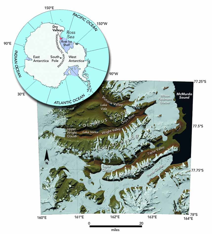
Immediately to the east of the Transantarctic Mountains, the Dry Valleys extend from the polar plateau seaward toward McMurdo Sound, an arm of the Ross Sea, roughly sixty miles away. The reason the valleys exist at all is that the Transantarctic Mountains dam the East Antarctic Ice Sheet, largely preventing it from flowing toward the sea.
At the floor of the valleys the average annual temperature is minus four degrees Fahrenheit (minus twenty degrees Celsius), and the annual snowfall amounts to less than half an inch of equivalent liquid water. The valleys are kept both cold and dry by cold, dense air masses that form on the polar plateau and then tumble down the valleys in what are called katabatic winds, displacing warmer air over McMurdo Sound. As the air descends from the plateau, it warms, amplifying its ability to evaporate moisture. Summer, naturally, is the “warm” season, with temperatures near freezing. In Wright Valley, the summer meltwater collects in the Onyx River, the largest “river” in Antarctica—a rather highflown description for what is hardly more than a trickle in the Antarctic summer and nonexistent the rest of the year.
The lakes scattered throughout the valleys are perennially covered by ice, which is typically ten feet or more thick. They would probably freeze completely were it not for the summer sun that warms them and the ice cover that insulates them during the winter. In fact, the bottom of Lake Vanda, in the heart of Wright Valley, is 226 feet deep; there, the water temperature is a comfortable seventy-nine degrees F (twenty-six degrees C).
Despite being fed by meltwater, most of the lakes are extremely salty. For example, the salinity of Lake Vida, in Victoria Valley, is seven times that of seawater. The basic reason for the high salinity is that the lakes are extremely old—old enough for salt to have built up, even though the waters that enter the lakes bring only minuscule amounts. Fundamentally, the lakes lose water as the top of each lake’s ice cover sublimes and is lost to the dry atmosphere. The lost ice is replaced by new ice forming at the bottom of the ice cover. In the process, salt gets left behind in the liquid water.
|

The glaciers of the Dry Valleys are as exotic as the lakes. The glaciers are said to be “cold-based,” which means that, unlike nearly all glaciers outside Antarctica, their bottoms are frozen. That property makes them act idiosyncratically. In places such as Greenland or the high peaks of the Alps, “wet-based” glaciers scrape the bedrock over which they flow, picking up substantial quantities of rocky debris. Where the ice melts, the debris accumulates in ridgelike piles known as moraines. Cold-based glaciers, by contrast, flow mainly by deformation: the ice itself flows like putty, pushed by its own inexorable weight. These glaciers pick up very little debris, cause little erosion, and leave only small moraines. Cold-based glaciers even look different. Instead of being thick rivers of ice full of crevasses, the glaciers within the Dry Valleys are flat and rather smooth; some are even shaped like pancakes. They, too, lose their ice mostly by sublimation, so little or no meltwater issues from them.
The enormous riverlike glaciers, such as the Taylor Glacier, that enter the heads of the major valleys do provide some liquid water. In summer they absorb solar heat, which melts the subsurface ice, leaving, within the glaciers, bowl-like pools called cryoconite holes. Because the summer air temperature is commonly still below freezing, the “holes” remain sealed by ice. Nevertheless, the water collects in small, coalescing passageways and eventually trickles out of each glacier.
Where liquid water does occur, life finds a toehold. The cryoconite holes, encased in ice, host communities of bacteria. The same organisms also occur in the lakes of the Dry Valleys, where they form algal mats. Sometimes pieces of the mats become encased in ice that migrates upward as the top of the ice sublimes. The process takes a long time, and microbial mats as old as 2,800 years have been identified. Besides bacteria, life is limited to a few lonesome lichens, which grow on protected rock surfaces, and to several species of microscopic worms known as nematodes, which live in the soil in the few places that become damp in summer.
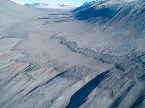
Since nearly all of Antarctica is covered by ice, one might reasonably suppose that the Dry Valleys were simply carved by glaciers that overtopped the Transantarctic Mountains. Unlike rivers, which tend to cut valleys that are V-shaped in cross-section, glaciers characteristically carve a U (think of California’s Yosemite Valley). The walls and floor of the lower reaches of the Dry Valleys are indeed shaped like a U, but to the practiced eye the U looks too wide and too shallow to have been solely glacial.
|

The most telling evidence of how the valleys did form occurs at high elevations, where geologists have discovered remnants of flat surfaces interrupted by steep-walled valleys. The latter valleys appear to be relics of river erosion 55 million years ago, when the climate was semiarid and Antarctica had no ice. In those days, in a sense, Antarctica did not exist at all. It was still attached to Australia as part of a larger continent known as Gondwana. There are places on Earth today that may bear a close resemblance to the Antarctic landform back then. One of them is the Colorado Plateau of southern Utah and northern Arizona, where seasonal rivers and streams have carved sinuous valleys with flat floors and steep semicircular walls.
The Antarctic ice cap began to form much later than the valleys did, about 34 million years ago. The fundamental cause was the opening of the Drake Passage, the part of the Earth’s great Southern Ocean that separates Antarctica from South America. The newly circumpolar ocean established a circumpolar current that blocks the southerly flow of warm water and thermally isolates Antarctica from the rest of the world. In contrast to the Arctic, which is highly sensitive to global climate change, the Antarctic climate has remained relatively stable for millions of years.
Early on, glaciers did cover much of the Dry Valleys. The glacier traces are hard to miss: rock surfaces have been scoured smooth, and rocky, gravelly debris known as glacial till has been scattered throughout the high valleys. But by about 14 million years ago, the glaciers—except for the small, cold-based glaciers of today—had largely disappeared from the valleys. How do geologists know? On some of the surfaces high above the valley floors, delicate volcanic ash deposits, some as old as 13.6 million years, lie just beneath the desert pavement—the loose rock and gravel too heavy for the wind to have blown away. Those regions of the Dry Valleys have remained hyperdry, hypercold, and glacier-free, at least since the ash fell.
|
I don’t mean to suggest that nothing has happened "recently." Low parts of the valleys were flooded by the sea: nine-million-year-old sediments, typical of the sediments at the bottoms of fjords, remain in the floor of Wright Valley. Similar deposits, aged between 6 million and 3.4 million years, occur in Taylor Valley. Since then, the region has been uplifted—and so the major valley floors are now mostly a few hundred feet above sea level. There was also a period of glacial advance, about 3 million years ago, when the Taylor and Wright glaciers expanded into the lower parts of their valleys and left deposits of till as their calling cards. At various times, sea ice has also invaded the lower valleys. In brief periods of relative warmth, glacial meltwater accumulated behind this ice to form small, temporary lakes. Their sites are marked today by local beds of sediment in the valley floors. Yet none of these events fundamentally altered the landscape; the vista we gaze on today has remained largely unchanged for at least 14 million years.
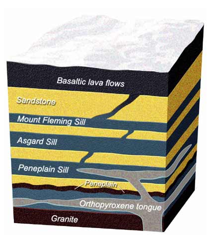
In today’s valleys, the Ferrar dolerites occupy four massive sills, each between 330 and 1,150 feet thick, interconnected by a series of dikes [see illustration below]. The intricacy of the array is accompanied by a wide variation in the composition of the rocks—a variation presumably related to the way the magma solidified. Unlike water, which freezes at a single temperature, magma freezes over a temperature interval. Most basaltic magmas are completely molten at 2,200 degrees F (1,200 degrees C) and do not become completely solid until the temperature falls to about 1,650 degrees F (900 degrees C). As the magma cools between those two temperatures, different minerals crystallize, or freeze out, at different temperatures. These minerals are not the same in composition as the magma itself. Therefore, as crystals form and sink or otherwise separate from the magma, the composition of the residual magma changes.
In a cooling basaltic magma, the first mineral to crystallize is usually olivine, a magnesium silicate (Mg2SiO4) that also includes some dissolved iron. In the case of the Ferrar dolerites, the first to freeze out was orthopyroxene (MgSiO3 with about 15 percent dissolved iron). Because orthopyroxene—and, for that matter, olivine—both have a higher proportion of magnesium than magma does, the magnesium content of the residual magma falls as these minerals crystallize. As cooling continues, plagioclase (a mixture of two kinds of aluminum silicates) and the pyroxene mineral augite (a magnesium silicate mixed with some iron) form.
The distribution of orthopyroxene proved to be our most telling clue for understanding the Ferrar dolerites. Looking closely at the rocks, we could see clear differences among the sills. Some are made up of dense, black, homogeneous basalt, with no visible mineral grains. Others have varying abundances of orthopyroxene crystals suspended in otherwise fine-grained rock. In consequence, the rock varies from 3 percent to 12 percent magnesium, depending entirely on the proportion of orthopyroxene.
|

Marsh and his students have meticulously mapped those proportions. The maps show that orthopyroxene crystals are distributed within the sills in great tongues, sometimes extending for tens of miles along the sills. The orthopyroxene-rich tongues are thickest—occupying perhaps half the height of a sill—where the sills appear to have filled from their feeder dikes, and they thin from the filling points toward the more distant parts of the sills.
Given the high melting point of orthopyroxene, its distribution into tongues suggests it froze out of the melt deep in magma chambers, before it reached the sills. Crystals of the mineral were then carried in suspension by the upward-moving magma and forced toward the center of the flowing slurry.
When the flow of magma intruded between layers of rock as a sill, the liquid began to solidify at the sill margins. The “solidification front” then proceeded inward as the basalt continued cooling. Meanwhile, the suspended orthopyroxene crystals, most of which were now near the center of the sill, slowly settled into the lower part of the magma in which they were suspended. When the solidification front moved entirely through the sill, it preserved the tongue-shaped distributions of orthopyroxene crystals we see today in the valley walls.
Elsewhere in the world, geologists have studied vast bodies of well-layered igneous rocks. Some of those rocks hold important deposits of metals such as platinum, for reasons that may be related to the rock-layering process. The layering has thus engaged the attentions of several generations of earth scientists, who continue to wonder not only about ore deposits, but also about the larger lessons the layered rocks may hold. In the Dry Valleys of Antarctica, where the Ferrar dolerites solidified rapidly, geologists have caught the layering process in the act. Thanks to the fortuitous circumstances that keep the landscape free of ice, the Dry Valleys are among the planet’s best places to study how various kinds of rocks form, and even how the deep Earth organizes itself.
![]()
 A geologist and curator in the department of earth and planetary sciences at the American Museum of Natural History in New York City, Edmond A. Mathez studies the geochemistry of the volatile elements. His research interests include the solidification of large magma bodies, the origins of platinum deposits, the electrical properties of rocks, and the early Earth. He has done fieldwork in many parts of the world, from the platinum mines of South Africa to the ancient rock-strewn mountains of Greenland. This past January he joined a group of geologists on an expedition to the McMurdo Dry Valleys of Antarctica, to study the ancient basalt deposits known as the Ferrar dolerites. His most recent article for Natural History, “A Birthstone for Earth,” on zircon crystals, was published in May 2004.
Copyright © Natural History Magazine, Inc., 2005